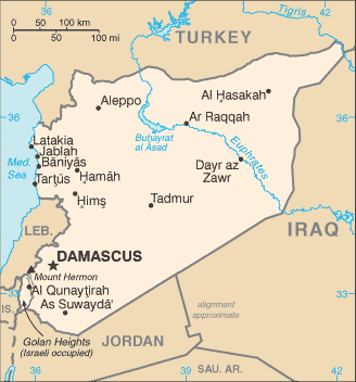
 Syria (Arabic: سوريا or سورية ), officially the Syrian Arab Republic (Arabic: الجمهورية العربية السورية ), is a country in the Middle East, bordering Lebanon to the west, Palestine to the southwest, Jordan to the south, Iraq to the east (see also: Iraq Maps), and Turkey to the north. The modern state of Syria attained independence from the French mandate of Syria in 1946, but can trace its historical roots to the fourth millennium BC; its capital city, Damascus, was the seat of the Umayyad Empire and a provincial capital of the Mamluk Empire.
Syria has a population of 19 million, of whom the majority are Arabic-speaking Sunni Muslims, as well as 16% other Muslim groups, including the Alawi, Shiite, and Druze, and 10% Christian.
Since 1963 the country has been governed by the Baath Party; the head of state since 1970 has been a member of the Assad family.
Syria's current President is Bashar al-Assad, son of Hafez al-Assad, who held office from 1970 until his death in 2000.
Historically, Syria has often been taken to include the territories of Lebanon, Israel and the Palestinian Territories, and parts of Jordan, but excluding the Jazira region in the north-east of the modern Syrian state. In this historic sense, the region is also known as Greater Syria or by the Arabic name Bilad al-Sham (بلاد الشام ). Since the Six-Day War in 1967, Israel administers the disputed Golan Heights to the southwest of the country; a dispute with Turkey over the Hatay Province has subsided.
The name Syria comes from the ancient Greek name for the former colonial territories of Assyria such as Canaan and Aram.
More...


No comments:
Post a Comment